
Where is this restaurant?
Where is this restaurant?
-
-
-
-
-
Where is this restaurant?
-
Post #1 - October 28th, 2009, 10:00 am
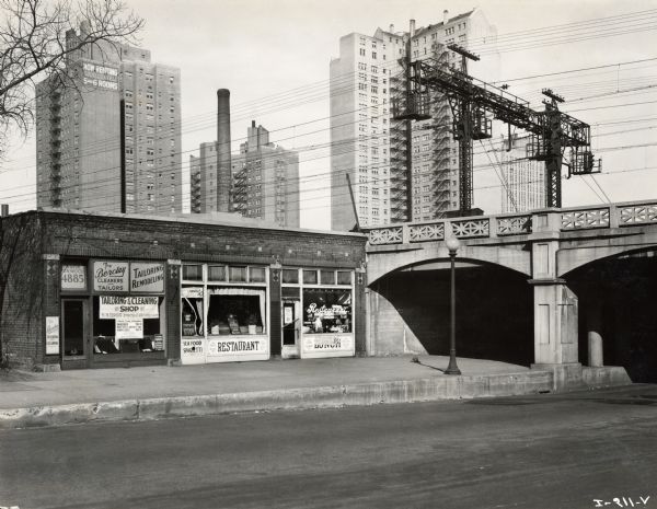
Does anyone now the exact location of this restaurant? ....and what is there now? The photo is from 1932.On a journey to find out what the American road tastes like
www.eatingtheroad.wordpress.com
-
-
-
Post #2 - October 28th, 2009, 10:28 amCould those be the Illinois Central (IC) tracks with all the electric wires? If so, it would be the South Side somewhere. Not sure what other railroads were electric back then. Also can't tell if the 4885 is a phone number or an address.Coming to you from Leiper's Fork, TN where we prefer forking to spooning.
-
-
-
Post #3 - October 28th, 2009, 10:40 amThe street runs perpendicular to the tracks, suggesting it's an East-West street, but if the 4885 is an address it doesn't make any sense (4885 West is too far, and there's no 4885 East). If it's a North/South address then it's either North of Lawrence or at 49th Street. Does not look like Uptown (well, it looks like it could be Uptown, but not at that location), maybe it's the South Side.
-
-
Post #4 - October 28th, 2009, 10:46 amRick T. wrote:Could those be the Illinois Central (IC) tracks with all the electric wires? If so, it would be the South Side somewhere. Not sure what other railroads were electric back then. Also can't tell if the 4885 is a phone number or an address.
If it's an address, that doesn't give too many options, eh? 4885 S Western, 4885 S California, 4885 S Kedzie? There's a 48th Pl, so those addresses are plausible. If so, those tracks are now mostly the Orange Line, but it probably was IC back when this picture was taken.
So my guess would be one of those three addresses, or +2 for the restaurant. In any case, I think that whatever was there is long gone now, but maybe someone can look through the older phone books.
-
-
Post #5 - October 28th, 2009, 11:00 amThat's Hyde Park, isnt it? Is that the Powhatan Building in the background? Could it be between 47th or 51st? That would jibe with the address.
-
-
Post #6 - October 28th, 2009, 11:02 amThe Chicago Historical Museum has city directories that might be help you determine where this is."The only thing I have to eat is Yoo-hoo and Cocoa puffs so if you want anything else, you have to bring it with you."
-
-
Post #7 - October 28th, 2009, 11:05 amDoesn't anyone watch CSI?

Look at the shadow from the pole in the foreground, then look at the lack of leaves on the tree. It would be impossible to get that shadow on a north-south street at the time of year when no leaves are on the tree.
It is an east-west street, and the building is on the north side of the street.
-
-
Post #8 - October 28th, 2009, 11:17 amYes, those towers are in Hyde Park, east of the IC/Metra tracks. So that corner should be Hyde Park Blvd and S Lake Park, but nothing is there now. I wonder if the building shown was demolished to widen the street of Lake Park?
(Rene G will undoubtedly have more details!)
-
-
-
Post #9 - October 28th, 2009, 11:30 amIn the city of Chicago, the odd numbers are on the south or east side of the street.
-
-
-
Post #10 - October 28th, 2009, 11:33 amYeah, so it seems the 4885 isn't a street number. Wonder what it is, though.
[img]http://img.skitch.com/20091028-pkwe1rt2b9tj923gn7rpw2h341.jpg[/img]
-
-
Post #11 - October 28th, 2009, 11:52 amThe cleaners says "The Barclay," it seems. There's an old apt. building of the same name at 4940 South East End Ave......
-
-
Post #12 - October 28th, 2009, 11:57 amgleam wrote:
Yeah, so it seems the 4885 isn't a street number. Wonder what it is, though.
I've magnified the photo to double the size, but the resolution doesn't hold well but I'm thinking it's the telephone number: Kenwood 4885.
-
-
Post #13 - October 28th, 2009, 12:02 pmcan't you just pull up the google maps backup from 1932?
-
-
Post #14 - October 28th, 2009, 12:29 pmOK, so the building with the pitched roof is the Barclay and the Powhatan is in the distance. I'd guess this is Hyde Park and Lake Park, before a second, east lane was added to Lake Park.
-
-
Post #15 - October 28th, 2009, 1:11 pmAccording to a friend of mine:
Could it be 57th & S Lake Park? There is now a station on the South Shore line at 57th (a station there would be seen in the old photo), but it seems the Metra station was moved from 59th to 57th in 2004 -- other pics of overpasses (I've not seen a pic of the 57th overpass) have strait slats, instead of the cross pattern in the old photo...
-
-
Post #16 - October 28th, 2009, 1:20 pmJeffB wrote:OK, so the building with the pitched roof is the Barclay and the Powhatan is in the distance. I'd guess this is Hyde Park and Lake Park, before a second, east lane was added to Lake Park.
Hyde Park Boulevard is 51st Street, so the 4885 number wouldn't work for that supposition (of the street address being of Lake Park Ave.).
-
-
Post #17 - October 28th, 2009, 1:36 pmPie Lady wrote:According to a friend of mine:
Could it be 57th & S Lake Park? There is now a station on the South Shore line at 57th (a station there would be seen in the old photo), but it seems the Metra station was moved from 59th to 57th in 2004 -- other pics of overpasses (I've not seen a pic of the 57th overpass) have strait slats, instead of the cross pattern in the old photo...
57th and Lake Park doesn't look much like the photo. I do think Amata is right that it's Hyde Park & Lake Park, before Lake Park was expanded (see my google street view image above).
I may drive down to that intersection and take a photo from the right perspective, but I'm pretty sure that she's right about the location.
-
-
Post #18 - October 28th, 2009, 1:40 pmYup - I know that underpass well. Recognized the tracks and background buildings, building with restaurant doesn't exist now. I can run past there at 5 tonight if anyone is curious (post specific questions here), don't have my camera, though.
-
-
Post #19 - October 28th, 2009, 1:42 pmThat looks right. Does anyone know when the building would have been torn down? When did they widen the road?
Thanks for all your CSIing by the way
On a journey to find out what the American road tastes like
www.eatingtheroad.wordpress.com
-
-
Post #20 - October 28th, 2009, 1:46 pmThere was massive urban renewal in the Hyde Park neighborhood during the 1950s and 60s, with many small businesses displaced. The Hyde Park volume in the Images of America series has more details about it...
-
-
Post #21 - October 28th, 2009, 1:57 pmEating The Road wrote:That looks right. Does anyone know when the building would have been torn down? When did they widen the road?
Thanks for all your CSIing by the way
Where'd you get the photo / why the interest in the location? Fun little project, in any case.
-
-
Post #22 - October 28th, 2009, 2:26 pmBill wrote:JeffB wrote:OK, so the building with the pitched roof is the Barclay and the Powhatan is in the distance. I'd guess this is Hyde Park and Lake Park, before a second, east lane was added to Lake Park.
Hyde Park Boulevard is 51st Street, so the 4885 number wouldn't work for that supposition (of the street address being of Lake Park Ave.).
Implicit in my agreeing with Amata was my acceptance of the phone # suggestion regarding that number. Based on the restaurant/dry cleaner's situation vis a vis the buildings (which are closer to the 5000 block and also north of the pictured corner), and the north side of the street location, 4885 does not work as an address, unless the addresses changed, which I don't think is the case. It is confusing, though, that the (presumed) phone # is so close to what could be a nearby address.
-
-
Post #23 - October 28th, 2009, 2:29 pmSantander wrote:Eating The Road wrote:That looks right. Does anyone know when the building would have been torn down? When did they widen the road?
Thanks for all your CSIing by the way
Where'd you get the photo / why the interest in the location? Fun little project, in any case.
Glad you enjoyed the hunt. It was from a friend and he found it in the WI Historical Society gallery. He was looking for old restaurant and diner photos.On a journey to find out what the American road tastes like
www.eatingtheroad.wordpress.com
-
-
Post #24 - October 28th, 2009, 2:43 pmEating The Road wrote:... When did they widen the road?
Okay, here's something from 1956 discussing the urban renewal plan, including relocating Lake Park east to be adjacent to the IC tracks:
http://ddd-hph.dlconsulting.com/cgi-bin ... locate-all
-
-
-
Post #26 - October 28th, 2009, 7:30 pmVery cool!!! Thanks for that
On a journey to find out what the American road tastes like
www.eatingtheroad.wordpress.com
-
-
Post #27 - October 29th, 2009, 5:46 amSantander wrote:
Where'd you get the photo / why the interest in the location? Fun little project, in any case.
This has also been running on roadfood.com embedded in a thread about an old photo of segregated restaurants.
-
-
Post #28 - October 29th, 2009, 9:44 amJust call the phone number and ask them


